in green,
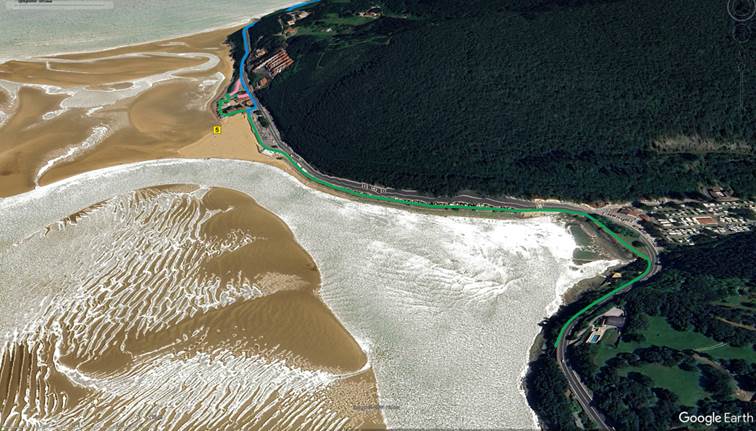
This route runs through the area known as Antzora.
It covers a distance of 1.14 kilometers (one way). It is mostly flat with only a few gradients, with ramps as an alternative. Only the last 200 meters south of the section have a 4% gradient .
Along this route there are rest areas , some public restrooms (open from June to September) and several bars and restaurants , mainly open during the summer.
- - - DETAILED DESCRIPTION WITH IMAGES - - -
As indicated in the description of parking P1, to avoid curbs, it is advisable to access the sidewalk from either end of the parking lot.


The alternatives are curbs or slightly lowered curbs, one of which is frequently blocked by parked cars.


To describe this route in detail, we will divide it into two parts: the one to the south and the one to the north of the P1 parking lot.
- - -
The southern part of parking lot P1 , parallel to the road, is mostly made of stamped concrete and is bordered on the sea side by a wooden fence.

Before the final curve, after the bus stop, the road transitions to gravel on firm ground, with a curb where the surface changes. There is tactile guidance to the zebra crossing.

At the bend there is a very pleasant shaded rest area with beautiful views.

After this, the 200 m climb begins with a 4% gradient and asphalt surface,

To reach the access to a small pier from where you can once again enjoy wonderful views even on rainy days, the access space is small and has a step.

There are no benches at that point, but there are two halfway along, at an old viewing point.

- - -
The northern part of parking lot P1 begins with a sidewalk that is frequently occupied by the bar-restaurant terrace, so it is common to drive on the road (only for access to buildings and services) and to which there is a ramp.


Later the road surface is smooth stone, with beacons at some points.

In this area there are different alternatives with ramps of varying steepness.

