
Portugalete is part of the Camino de Santiago, on its Northern Way, declared a World Heritage Site by UNESCO on July 5, 2015.
The Camino passes through the upper part of Portugalete, offering excellent views, the historic center, and the main thoroughfare of modern Portugalete. The town has a municipal hostel for pilgrims.
The presence of the town of Portugalete on the Coastal Way of pilgrimage to Santiago is confirmed by a direct Jacobean source, that of the Armenian Bishop Martyr of Arzendjan, who in 1494 made the round trip along this coastal route and on his return settled in "the great city of Portugalete".
The Northern Way of St. James runs along the Cantabrian coast from Irún to Santiago de Compostela. In Asturias, it splits into two branches: the Coastal Way and the Primitive Way. It was one of the busiest routes in the early years of pilgrimage. Pilgrim hospitals and monasteries remain as evidence, along with documents that attest to the passage of pilgrims in the 10th century.
The reasons for undertaking the pilgrimage were varied. The most common were devotion, seeking forgiveness for sins, fulfilling a vow, or seeking a cure for illness. The growing number of pilgrims and the increased security along the route led thousands of merchants and knights to join the Camino, using the pilgrimage to satisfy their curiosity about foreign people and lands.
Click to watch or listen to a video about the Camino in Portugalete (7:12´, by Oscar Terol)
Click to watch or listen to a short video about the Northern Way (0:55´)
Click for more general information
DESCRIPTION AND ACCESSIBILITY:
The Camino de Santiago enters Portugalete through the municipality of Sestao, at the southeastern edge near the estuary. For 750 meters it runs parallel to the estuary, entering the historic center only to pass by the Basilica and exiting after 200 meters.
For 550 meters, the path heads straight inland, leaving the estuary behind us. We reach the cemetery and the outskirts of the town. We cross to the other side of the road to get around a roundabout, continue in the same direction, and after 500 meters, we reach the end. The Way then passes through the municipality of Ortuella.
For most of the route, the ground is smooth, with some indentations and occasional tactile paving. The section through the historic center presents more challenges, as described in the route description.
The following shows the route profile according to Google Earth
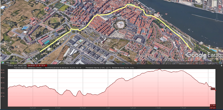
It shows 2 kilometers, with a difference in level of about 25 meters in altitude, average slopes of 5.2% on ascents and 5.6% on descents and with maximum slopes of 21.8% and -22.7%.
The downhill slopes around the Basilica are particularly noteworthy, with a 40-meter stretch at a 19-24% gradient on the lightly trafficked roadway and wide steps on the sidewalks. In the historic center, the Way includes a 10-15% incline. Later, there's an 8-10% gradient on Gregorio Uzquiano Street for 300 meters, reaching 14% if you wish to access the new chapel. At the entrance to the cemetery, there's a ramp to avoid the 16% gradient of the steps, and at the end of the route, a downhill slope of approximately 300 meters that doesn't exceed 8%.
There are banks or adjacent parks along much of the route.


